Tuesday, 19 November 2013

Codissago

Codissago... home of the master raftsmen of the Piave, the zattieri di Codissago.  The village can be found on a map of the region to the north of Belluno, on the left bank of the Piave River.  Castello Lavazzo can be found on the right bank, to the north, while Longarone is situated on the right bank, to the south.  (‘Right’ and ‘left’ are as seen by a zattiere standing on a raft looking downriver).


N to S: Castello Lavazzo, Codissago and Longarone
Carte e Pianta Turistiche Tobacco sheet 21

The zattieri di Codissago not only navigated the most treacherous waters of the Piave, they also built the rafts in Perarolo, having walked through the night to start work on their construction at daybreak.  


Commemorative logo from the 2008 walk
In 2008, my daughter Jenny and I were invited to join the descendants of the zattieri di Codissago on their annual commemorative walk.  

Around midnight we left our hotel in Belluno and, in a car borrowed from an Italian friend (thanks, Barbara!), drove to Codissago.

The walk commenced at a pre-arranged house in the village and, through the night, stopped at many on the small villages en route.  The first stop was at Termine where refreshments were provided for us all.  We were joined there by two cars driven by carabinieri who were our escorts on the long walk north.
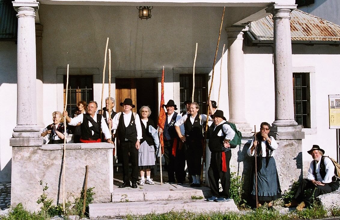


It'd been a long hike through the night, but we were nearly there...
Photograph © Peter Alexander Gray 2008


By daybreak we were on the final approach Perarolo, where the photo above was taken.  The reception in Perarolo was marvellous, with much feasting and celebration!


Photograph © Peter Alexander Gray 2008
In Codissago, the church where Lucia and Saverio were married still stands, but times change, and all commercial rafting on the river has now ceased.  This was partly due to the arrival of the railways - but also the progressive industrial and agricultural use of the water resources up to modern times has taken its toll.   From the 1940s onwards, water was taken from the rivers and streams of the Piave valley via a network of dams and tunnels for the generation of HEP (hydro-electric power) at the power generating station at Sovèrzene.  Some of the water was also diverted onto farms for the irrigation of crops.  As a result, today the Piave has no longer the depth of water required for commercial rafting.

Apart from one occasion (for a RAI TV documentary, when water was released from the dam near Pieve di Cadore), there has been no rafting of the Piave in recent times.   

The quay where the zattere were to be seen moored in twos and threes has gone, and the small quarry close by has been gated up, and is used now as a centre for driving instruction for would-be motorists!  


The church still plays a major part in the lives of the people of Codissago
Photograph © Peter Alexander Gray 2008

The church may be grand and beautiful, but a hundred years or so ago it wasn't the only place of worship...


Small is beautiful?
Photograph © Peter Alexander Gray 2008
A perspex screen prevents entry to this tiny chapel, once a place for Christians to meet and pray together.  To the top left of the photograph you can glimpse the bell tower of the main church of Codissago.


Coro di Codissago and zattieri standing on a three-section zattera
In the town, life goes on.  There, as everywhere, the future is with the young people, the new generation.  Coro di Codissago are a local choir (see the link in Useful Links), seen here standing on one of a number of zattere constructed and sailed down the Piave, filmed for the RAI TV program.  Note the clever, simple mechanism for joining the sections together - this mechanism allowed the rafts to pass over the rough river bed without the sections breaking apart.  The 'rope' used by the zattieri when constructing the rafts was made simply by twisting lengths of hazel shoots.  The shoots were immersed in water in stone troughs for long periods before  they were twisted (this sheared apart the fibres and made the hazel pliable) to make the 'rope'.  A traditional zattera had two forward-facing oars at the front and two trailing oars at the stern.  The handle of one of the forward-facing oars can be seen at the left of the photo.


The bell tower of the church at Castello Lavazzo
Photograph © Peter Alexander Gray 2008

Across the Piave, upstream from Codissago, is found the the village of Castello Lavazzo.  So-named in the time frame of The Door of Perarolo, the place name nowadays has been changed to Castellavazzo after a recent referendum.  

To the back of the village was a quarry where stone blocks were extracted for building stone, columns, lintels and so forth.  These were passed on a conveyor close by the church across the river to Codissago and thence, via the rafts, downriver.

The travel writer Amelia Edwards sketched the village in the early morning while staying at the inn at Longarone in 1872.  The bridge over the Piave (bottom right-hand corner) leads to Codissago.  The description of the inn in her book Untrodden Peaks and Unfrequented Valleys is the basis of the description on the inn where Padrig Droug had his office in The Door of Perarolo.   


Castello Lavazzo as sketched in 1872
She says: 
'LONGARONE , seen at six o'clock on a grey, dull morning, looked no more attractive than at dusk the evening before. There had been thunder and heavy rain in the night, and now the road and footways were full of muddy pools. The writer, however, was up betimes, wandering alone through the wet streets; peeping into the tawdry churches; spelling over the framed and glazed announcements of births, deaths, and marriages at the Prefettura; sketching the Pic Gallina, a solitary conspicuous peak over against the mouth of the Val Vajont, on the opposite bank of the Piave; and seeking such scattered crumbs of information as might fall in her way.'  


I'm afraid she wasn't very complimentary in general about her stay in Longarone!  Before breakfast that same morning she also sketched the Spiz Gallina - the Hen's Beak.  In the book she labels it 'Pic Gallina'.


Looking South down the Piave valley from Castello Lavazzo
Photograph © Peter Alexander Gray 2008
In modern times the 'Hen's Beak' still towers over the left bank of the Piave (you can glimpse the river, shrouded by trees along its banks, at the foot of the image towards the centre), and the church at Codissago (seen left of centre) remains.  But Longarone as Amelia Edwards and others at that time knew it was largely destroyed, fifty years ago, in the Vajont Dam disaster of October 1963. Yet in those fifty years much new industry has arrived into Longarone, and modern factories have been built, providing work for the people of  succeeding generations.  The zattere no longer ply the river trade, but the community around the towns of the valley hereabouts is alive and vibrant.

Note: This blog supports readers of The Door of Perarolo, a historical novel set in Cadore, Italy in the early nineteenth century.  You may examine feedback from readers in the UK here and in the US here.  The Door of Perarolo is a Kindle ebook comprising 140 chapters.  It can be downloaded from Amazon sites worldwide.  The launch post of this blog gives further details.  The second post provides links to maps, etc.


Monday, 11 November 2013

The Beautiful One

The name of the city of Belluno, is frequently mistranslated as 'Beautiful One', though its origin is from a Gallic, pre-Roman name based on bel  and dunum, and indicating a site on a high ground or a fortress.
At the suggestion of his sister Pauline, Napoleon gave Marshal Victor the title of Duke of Belluno - with the Emperor perhaps not realizing the reason for her proposal.  The truth was, Victor had a formidable appetite for wine and his glowing, red cheeks had earned him the title ‘Victor Beausoleil’.    Pauline had said, laughing, after the title had been conferred, ‘He will be the beautiful sun and the beautiful moon, now!’  (A pun on ‘bella luna’.)


A band playing in the Campedèl

The painting above hangs in the Museo Civico di Belluno and is by Alessandro Seffer (1832 - 1905), a local painter whose paintings of scenes in the Veneto (Venetia) region let us glimpse life in towns in the Piave valley as it was in his time.
In the Roman era the site of the Campedèl was a place - a small plateau - where sacrifices were made to the gods.  By the 19th century it was a marketplace where produce from the country areas surrounding Belluno was brought for sale.  Today it is the Piazza dei Martiri, named after the local people who were executed there in WW2 during the fight against the Nazi occupation.


 Photograph © Peter Alexander Gray 2008
The Piazza dei Martiri

Nowadays, in the Piazza dei Martiri, people stroll around or relax on the benches to read the local newspaper or - like my daughter Jenny in the photo above - sit by the fountain.  Most of the buildings described in The Door of Perarolo remain, though the ruined castle which once occupied the SW corner of the Campedèl has completely vanished.  

The Porta Ussolo (renamed the the Porta  Dante after the Unification), from where the sergeant and the sentry watched Fortin's arrival in The Door of Perarolo, can still be found on the south side of the Piazza, as can the more imposing Porta Dojona. Through either we can get glimpses of old Belluno, the ancient walled city.   

The Via Rialto, passing through the Porta Dojona, leads us along to the Piazza Erbe.  Here the fruit and vegetable market comes alive from the early hours.

Photographs © Peter Alexander Gray 2008


Yet Belluno is more than entitled to call herself 'The Beautiful One'.  She is a jewel of a city perched on her plateau over a wide plain that hereabouts is the Piave valley , surrounded by hills - and what hills!


 Photograph © Peter Alexander Gray 2008

The present-day bridge over the Piave 

The stone bridge over the Piave was carried away by flood waters in 1882 and today only a single arch - from where the above photo was taken - still stands.  The river here is, as elsewhere, lined with trees (timber was the lifeblood of the Piave valley for centuries).  In the distance to the south can be seen the hills (though these are as nothing compared to those to the north of Belluno, in Cadore).


  Photograph © Peter Alexander Gray 2008

The cathedral seen from the bridge over the Piave

The cathedral of San Martino can be seen from many miles away, from all points of the compass.  It dates from 1517.  The tourist office - well worth a visit for maps and postcards - is located close by.


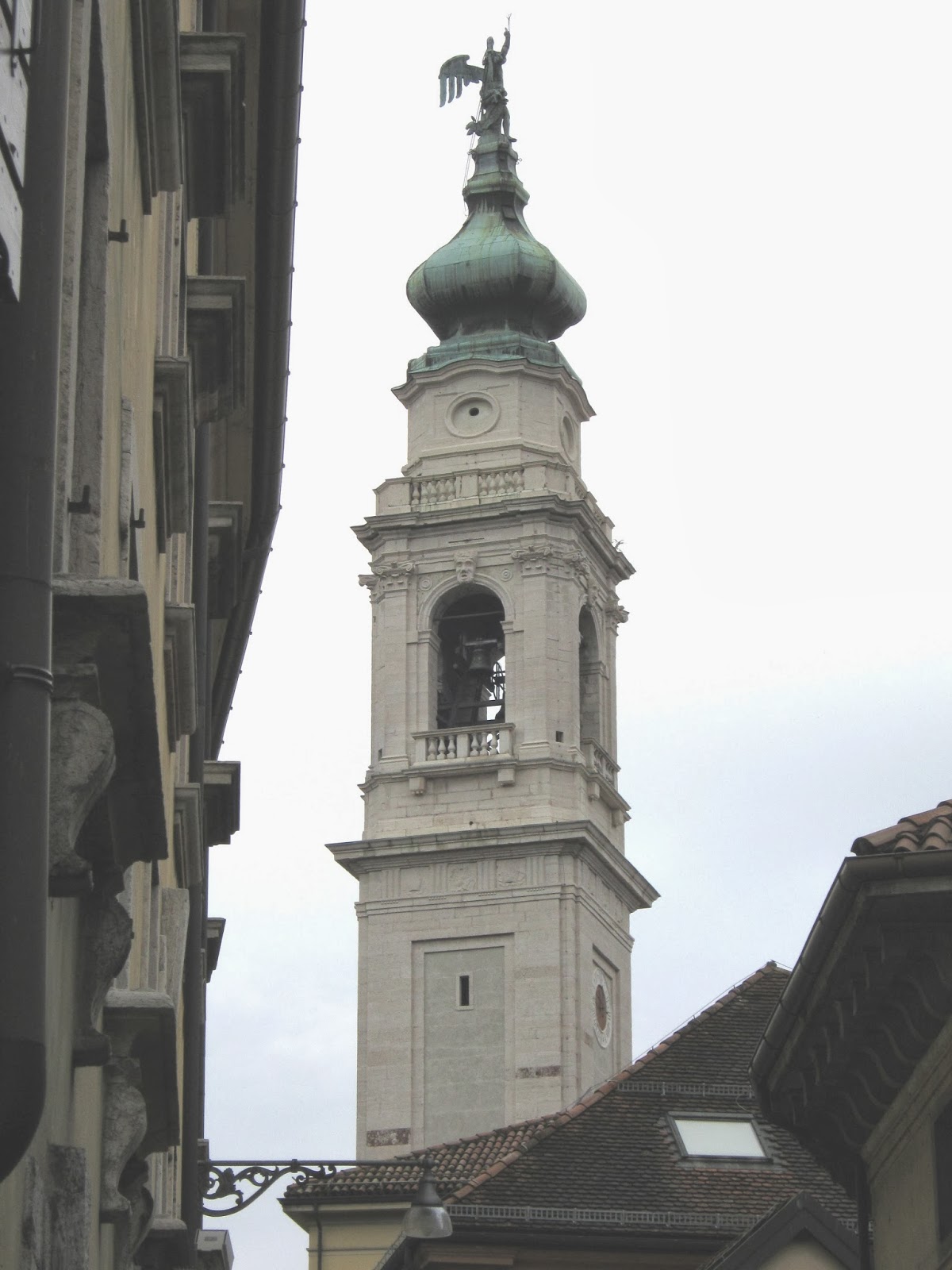
Gabriel stands atop the 18th-century bell tower, designed by Filippo Juvarra and built from blocks of white stone quarried at Castello Lavazzo (now renamed, after a recent referendum, 'Castellavazzo') and brought downriver by zattere (rafts) from Codissago. 


                        Photographs © Peter Alexander Gray 2012


The message to the faithful seems to be clearly indicated by the upraised finger: lead a Godly life, or expect a bolt from the blue.  In modern times a lightning conductor has been added as an extra precautionary measure.


Belluno is a city packed with wonderful places to visit and lovely things to see, and this post touches on but a few of them.  Further posts will attempt to fill in the gaps left by this one, but for the time being, for the next post, we will move on to... Codissago and Castello Lavazzo.


Note: This blog supports readers of The Door of Perarolo, a historical novel set in Cadore, Italy in the early nineteenth century.  You may examine feedback from readers in the UK here and in the US here.  The Door of Perarolo is a Kindle ebook comprising 140 chapters.  It can be downloaded from Amazon sites worldwide.  The launch post of this blog gives further details.  The second post provides links to maps, etc.


Wednesday, 30 October 2013

A Tale of Two Cities

The French, arriving in Venice, looted her treasures, destroyed churches and burnt records relating to old Venetian Republic, Serenissima.  All this was witnessed by Andrea Salvini, who was to live under successive occupations by the French and Austrian forces and would have, as a citizen of Venice (Venezia), loathed both nations - perhaps in equal measure.


The lions guarding the old arsenale - see Useful Links for video

Andrea Salvini was born in Venice in 1768 and died in his house there after suffering a stroke in 1819.  The works and achievements of Salvini, a talented and well-travelled naval engineer, are fully documented in Mario Marzari’s Progetti per L’Imperatore. 
It was Oscar Wilde who said that any fool can make history, but it takes a genius to write it.  Sadly, this means that researching historical fiction can be a headache for any author, as it is rare for two accounts (each aspiring to genius) of events in history to agree completely. 


A model of the Rivoli with one of the 'camels' in place

The history of the construction and loss of the Rivoli, intended to be the flagship of Napoleon’s new navy, is a case in point.  Who was really responsible (Salvini or Tupinier?)  for the ship’s design, and of the design of the ‘camels’ used to take her out of the lagoon at Venice and into the waters of the Adriatic?  On the fateful maiden voyage, did Capitaine Barré set sail for Ancona, Pola or Trieste?  Was she lost due to the Dalmatian crew abandoning the ship’s guns and fleeing below decks as some accounts state, or did she put up a brave fight ( as the British claimed) and only struck her colours when her rudder became disabled?


Historical accounts generally agree on one thing: Tupinier and Salvini disliked each other.  Tupinier, in his autobiography Mon Rêve, is quite clear in stating that using the ‘camels’ to float the Rivoli was his own idea (whilst acknowledging that the Dutch had originally pioneered their use).  Yet we know (see the chapter Il Viaggio di A. Salvini in Olanda e Francia in Mario Marzari’s Progetti per L’Imperatore) that Salvini travelled extensively in Holland and France in the period 1808 – 1809, and would clearly have known all about the use of the ‘camels’ in Holland as a result.
Jean-Marguerite Tupinier (pictured left in his latter years) was, like Salvini, an outstanding naval engineer.  He was born in Cuisery in Saône-et-Loire in 1779.  The son of a judge, his early life was marred by the arrest of his father during The Terror.  As a young man studying naval engineering, he described the day when he heard of his father’s release from prison as ‘the happiest day of my life’.  According to his own accounts, he seemed to strike up a rapport with Eugène Beauharnais, whose own father had lost his head to the blade of the guillotine.  But the friendship was to be short lived, due to Napoleon’s abdication in 1814.  Despite this and other setbacks, Tupinier’s career in France progressed steadily.  Once the initial displeasure shown by the Bourbon regime to an association with Beauharnais faded, he was recalled to the Paris HQ of the Ministry of Marine as Deputy Director of Ports. 


The Ministry of Marine in Paris
Photograph © Peter Alexander Gray 2009

 In later life he became involved more in French politics, speaking with authority on naval issues.  His career was remarkable in that it spanned not only the Resoration but two further revolutions, the last in 1848 causing him to step down from public life.  He died, childless, in 1850.


Napoleon's triumphal arch in the Tuileries
Photograph © Peter Alexander Gray 2009


The Ministry of Marine in Paris stands close by the Tuileries gardens, originally the site of a factory for making roof tiles.  The famous bronze horses, looted from St Mark’s Square in Venice, once stood atop Napoleon’s triumphal arch there.  After his abdication they were replaced by replicas and the originals returned to Italy. 


Napoleon himself had a flair, perhaps genius, for writing history.  The famous painting by Jacques-Louis David (above) is a brilliant piece of Napoleonic propaganda.The painting purports to show Napoleon leading his army up and over the Alps via the St Bernard's pass into Italy.


The truth, expressed clearly in Paul Delaroche’s 1850 depiction (above), is somewhat different... Eat your heart out, Pacienza!

Note: This blog supports readers of The Door of Perarolo, a historical novel set in Cadore, Italy in the early nineteenth century.  You may examine feedback from readers in the UK here and in the US here.  The Door of Perarolo is a Kindle ebook comprising 140 chapters.  It can be downloaded from Amazon sites worldwide.  The launch post of this blog gives further details.  The second post provides links to maps, etc.

Monday, 21 October 2013

A Glance at Old Perarolo

The river port of Perarolo was the most northerly port on the river Piave.  Here the waters of the Piave and the Boite, a major tributary, joined so as to provide enough depth of water to support commercial rafting.  After walking through the night upstream along the right bank of the Piave from Codissago, the zattieri di Codissago would arrive at Perarolo at daybreak to begin the construction of rafts.


When commercial rafting was at its height
 Colour tinted photo from an old postcard

The photograph above shows massive quantities of timber stacked along the right bank of the Piave at Perarolo.  Water, taken from the Boite river, was conveyed through a narrow channel (centre bottom of picture) to power the mills (a sawmill and a flourmill) at the southern end of the village.  Timber was also floated to the sawmills along this channel.  It was in this region - the southern end of Perarolo - that the rafts were assembled.
The church and campanile (close by the bridge) are not the same as those described in The Door of Perarolo.  A huge landslide blocked the course of the Boite River in 1823, forming  a natural dam.  The water pressure built up behind the frana blocking the Boite until it was sufficient to rupture the dam and sweep the frana away, and with it also a significant part of Perarolo.  Fortunately, the villagers, seeing the Boite riverbed dry, had sufficient warning to evacuate the population to higher ground.  The church was rebuilt in 1863 on a new site - by the bridge - but suffered further flood damage in 1882.  More problems with earthquakes and subsidence followed, and only the choir of the old church survives to the present day.  In 1906 the aisle and façade were reconstructed in wood under the direction of the Belluno master builder Luigi Croce, whilst in the same year the old campanile was demolished and replaced by the wooden one seen in the photograph in the post ‘Links to Maps’ of 25/09/13. 


Map showing the site of the cìdolo  at Sacco
Carte e Pianta Turistiche Tobacco sheet 16

After the Austrian re-occupation of Venetia a new road, the Cavallera was built to link Vienna with Venice through the Piave valley.  It leads north out of Perarolo, zigzagging up the mountainside below Damos.  If you look at the map, you can see at the first sharp bend of the Cavallera, a road leading down to the right bank of the Piave at Sacco.


The cìdolo at Sacco


Here was sited il cìdolo, a kind of covered doorway or portcullis in the river.  Men worked inside the cìdolo sorting the logs for the sawmills of the Piave valley.


The church of Sant’Anna
Photograph © Sally Givertz 2012

The tiny church of Sant’Anna, marked in the bottom left-hand corner of the map above.  The church dates from 1580.  I have added a link under 'useful links' to the Comunità Montagna Centro Cadore website, which gives more details about the church and Perarolo in general.


Finally… a personal announcement.  Sally, my editor, and I were married on the 27th September in a small ceremony at the registry office in Banff, a few miles from Gardenstown (known as ‘Gamrie’ to locals)where we live.  Sally has photos and more – if you would like to view please follow the link ‘My editor’s blog’ to the right of this post.


Note: This blog supports readers of The Door of Perarolo, a historical novel set in Cadore, Italy in the early nineteenth century.  You may examine feedback from readers in the UK here and in the US here.  The Door of Perarolo is a Kindle ebook comprising 140 chapters.  It can be downloaded from Amazon sites worldwide.  The launch post of this blog gives further details.  The second post provides links to maps, etc.

Saturday, 12 October 2013

Vauluisant Abbey

Vauluisant Abbey was founded in 1127 by Cistercian monks in the forests of the Alain valley.  The river Alain flows south past Vauluisant to join with the waters of the Vanne, a tributary of the Yonne, the broad stately river that flows through Sens.


Map showing the location of Vauluisant Abbey in Yonne


The abbey provided work for foresters, and as a young man Xavier Fortin, himself a forester’s son, worked in the woods surrounding Vauluisant Abbey.  


Letellier de Louvois’ 1692 plan of Vauluisant Abbey

The Alain provided water for the fish farm (to the right of the plan above).  A dovecote (the tower to the left) with a rotating cone of ladders at its centre allowed the monks to collect eggs for the kitchen.  Also to be found within the grounds were orchards and vegetable gardens.  Before Fortin’s arrival at the abbey the monks there, over the centuries, had enjoyed periods of expansion and prosperity, these interrupted by attacks on the abbey – notably during the religious wars of the 16th C, when the buildings were looted on several occasions.   During the Revolution, the monks were thrown out of the abbey, the latter becoming a vast demolition site.


Vauluisant in present times
Photograph © Peter Alexander Gray 2009


Much restoration has taken place since those times.  I would like very much to express my gratitude to Madame Demoulin, the present owner, and her wonderful team of guides, for giving me a private tour of the grounds and buildings of Vauluisant Abbey during my visit there in 2009.

Note: This blog supports readers of The Door of Perarolo, a historical novel set in Cadore, Italy in the early nineteenth century.  You may examine feedback from readers in the UK here and in the US here.  The Door of Perarolo is a Kindle ebook comprising 140 chapters.  It can be downloaded from Amazon sites worldwide.  The launch post of this blog gives further details.  The second post provides links to maps, etc.

Tuesday, 8 October 2013

Xavier Fortin


Le Grand Cerf (left of picture), in the Rue de Lyon, Sens.


The main protagonist of The Door of Perarolo is a Frenchman, Xavier Fortin.  Fortin’s father was a forester, who died in Xavier’s infancy.  Shortly afterwards the surviving members of the family, Mama, Lucien and Xavier, moved to Sens (in the district of Yonne).  His mother worked in the kitchen of a coaching inn there, Le Grand Cerf.  The photograph (above) of the Rue de Lyon was taken around the end of the 19th C.  A low wall is visible at the bottom left hand corner of the image.  Its function was to prevent people (possibly having had too much hospitality during an evening spent in Le Grand Cerf) falling into the waters of the abreuvoir on the far side.  The latter was a place for the watering of coach horses arriving at the inn.  On the opposite side of the street was La Bouteille, another inn (a man wearing a white apron stands in the entrance).  It is interesting to speculate what they might be thinking.  Did they know by that time that the coming of the railways would cause the demise of the old coaching inns?


Elephants from a circus passing through Sens watering in the abreuvoir.


The abreuvoir close by Le Grand Cerf (left).  I owe a debt of gratitude to Bernard Brouse of the Société Archéologique de Sens for assisting me in locating Le Grand Cerf, and I am grateful also for his subsequent kindness in sending me French newspaper cuttings relating to the inn when it was still functional. 


Looking into Sens from Le Grand Cerf
Photograph © Peter Alexander Gray 2009


Today the abreuvoir has been filled in.  This is the view looking into the beautiful city of Sens, seen from the spot where it was sited, outside Le Grand Cerf,.  The old town walls that were there in Fortin’s time have, like the abreuvoir, gone, though some of the buildings from the period remain.  A small plaque can be seen above the top window of the building on the right.   It shows evidence of the passage of Russian troops and cavalry through Sens en route to Paris.


Cossack bullet marks from February 1814.
Photograph © Peter Alexander Gray 2009

Le Grand Cerf still stands, but in modern times has been converted into apartments.  The Rue de Lyon has been renamed the Rue du Général de Gaulle.

Note: This blog supports readers of The Door of Perarolo, a historical novel set in Cadore, Italy in the early nineteenth century.  You may examine feedback from readers in the UK here and in the US here.  The Door of Perarolo is a Kindle ebook comprising 140 chapters.  It can be downloaded from Amazon sites worldwide.  The launch post of this blog gives further details.  The second post provides links to maps, etc.